
Engineer Research and Development Center - Environmental Laboratory
Risk and Decision Science Team
Wildfires
The United States Army Corps of Engineers water management is complicated by the presence of burn scars in the drainage basins that feed reservoirs, due to the changes in hydrology and geological flow risk that burn scars produce. The extent that these effects these are influenced by predictable atmospheric rivers is needed to better understand and develop decision support for West coast multi-hazards, especially those related to post-fire hydrology. Integrating hydrologic, atmospheric, and social sciences, this effort works towards a USACE decision support tool related to reservoir operations and emergency management. This project investigates statistical relationships of antecedent conditions using collected data sets to understand hydrologic watershed changes for pre- and post-fire conditions. (i.e., reservoir inflow distributions). Further, this work generates empirical models that consider uncertainty and predictability. Better forecasting of flood-inducing atmospheric river conditions related to burn hydrology will help emergency management prepare for potential natural hazards, which can save lives and reduce resource demands and associated costs, especially in infrastructure dense regions that are vulnerable to post-fire flood events. Better forecasting of fire-related hydrology changes will improve risk-informed decision making for water managers.
USACE water management is complicated by the presence of burn scars in the drainage basins that feed reservoirs, due to the changes in hydrology and geological flow risk that burn scars produce. These extent that these effects these are influenced by predictable atmospheric rivers is needed to better understand West coast multi-hazards, especially those related to post-fire hydrology and will help the USACE in decision support related to reservoir operations and emergency management.
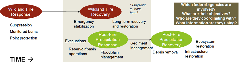
Investigate statistical relationships of antecedent conditions using collected data sets to see how watershed hydrology pre- and post-fire changes—ex: reservoir inflow distributions. Analyze uncertainty and predictability. Generate empirical models.
Better forecasting of flood-causing AR conditions related to burn hydrology will help emergency management prepare for potential natural hazards & disasters (saving lives and $, especially given infrastructure density in AR affected regions). Better forecasting of fire-related hydrology changes will help water managers make better decisions and improve flood risk management (saving $ and potentially lives).